The most unnerving thing about Old Maps Online is how little effort it takes to make the present look provisional. You type the name of a city, a village, a railway halt, or a patch of land that barely deserves a label, and the ordinary world begins to loosen. The street grid you trust for directions starts to feel like the latest draft of a much older argument. A river appears to have been moved. A field becomes a district. A road that feels permanent in the car turns out to be younger than the factory beside it. The site is not asking you to admire old paper. It is asking you to notice that place is an accumulation of edits.
Table of Contents
A search engine where the present is only the starting point
Most map archives make you arrive as a researcher. They greet you with a catalogue, a string of filters, a record number, and the faint sense that you should already know what you are looking for. Old Maps Online reverses that social contract. It lets ordinary curiosity lead. Start with a place you know. Zoom. Choose a period. Open a map. The first action is not “search the collection”; it is closer to “look under the world you already recognise.” That small change carries the whole experience. It turns historical cartography from a specialist room in a library into something closer to a trapdoor in the pavement.
The website calls itself a place to browse historical locations and search old maps through a timeline. That description undersells the emotional mechanism. The map is doing two jobs at once. It is a retrieval system, pulling scans from archives and libraries, and it is a visual argument against the fiction that cities, borders, neighbourhoods, and place names are fixed. The first job gets you in. The second is why you keep clicking. A normal search engine gives you pages about a place. This one gives you the place’s former self, often before your memory, your family stories, or the local council’s branding had a chance to tidy it up.
There is a particular shock in seeing your own area on an older sheet. Familiarity becomes evidence. You know where the supermarket is. You know the bend where traffic backs up. You know which ugly apartment block everyone uses as a landmark. Then an old map tells you that the same point was once orchard, barracks, marsh, quarry, railyard, cemetery, hamlet, or empty margin. The surprise is not that places change. Everyone knows that in the abstract. The surprise is seeing the exact geometry of the change, sitting on the same coordinates where you buy milk or wait for a bus.
Old Maps Online works because it understands that maps are not merely pictures of territory. They are compressed decisions. Someone chose what deserved a line, a colour, a label, a boundary, a flourish, a warning. Someone decided a village mattered but a settlement did not. Someone drew a military road with obsessive precision and left whole communities as a vague wash of ink. Someone made a river look obedient because the map needed it to be. Digital archives often treat such objects as documents with metadata attached. This site gives them a chance to misbehave again, because it puts them beside the current world and lets the differences speak.
The current portal indexes more than 500,000 maps supplied by archives and libraries that link back to their own material. That scale matters, yet it is not the most interesting thing about the project. The memorable part is its refusal to make scale feel abstract. Half a million scans sounds like storage. Search a specific river bend, former industrial suburb, or ancestral village, and that number becomes a possible encounter. It is a chance that some cartographer, surveyor, military office, railway company, local authority, or obsessive collector recorded the ground before it became what you see now.
What changes when a map becomes searchable by place
| What you do | What Old Maps Online changes | Why it feels different |
|---|---|---|
| Search a town or move the map | It looks for historical maps covering that location | The archive behaves like geography |
| Select a time period | It narrows your view through a historical timeline | Dates become something you can browse |
| Open a map record | It leads back to the holding institution | Discovery does not erase provenance |
| Compare old and current mapping | It makes physical change visible at the same coordinates | The past stops being remote |
The table makes the site sound tidy, which the actual experience is not. Old Maps Online is at its best when it produces a slightly messy chain reaction. You arrive to check a street name, find a nineteenth-century survey, notice an erased stream, open another sheet, discover a vanished station, then spend forty minutes wondering why a road takes such an odd turn. The website does not force a story on you. It gives you enough spatial proof that you begin writing one in your head.
That is why the project belongs in a list of internet discoveries rather than a list of research utilities. It has the rare quality of changing how you look after you close the tab. A map app normally answers a practical question: where is this, how do I reach it, what is nearby? Old Maps Online introduces a more destabilising question: what was here before the current answer hardened into common sense? That question follows you outside. You start seeing odd gaps in terraces, absurdly wide streets, orphaned walls, canals buried under roads, and parks whose awkward outlines suggest something was removed rather than planted.
The site also knows better than to flatten old maps into one visual style. Their differences are part of the reward. One sheet feels like a military instrument. Another is dense with property boundaries and field names. One reduces a city to a few bold routes. Another cannot resist decorating coastlines, mountains, or political claims. Moving across them is not only a trip through time. It is a trip through the changing moods of authority: the state that wants control, the merchant who wants a route, the engineer who wants measurement, the antiquarian who wants beauty, the army that wants an advantage.
A modern basemap gives you the comforting illusion that every location has been settled. It has standard symbols, consistent spelling, live traffic, satellite texture, and the calm voice of a system that expects to be right. Old Maps Online restores friction. It puts you in front of incomplete, biased, often beautiful attempts to describe the world. The maps may be careful, but they are never neutral. They have blind spots, scale problems, political assumptions, and the visual signatures of their makers. That is not a flaw to correct. It is the reason they remain alive.
The project deserves a first click for the obvious reason: it may show you your place before it became familiar. It deserves a second and third click for a more interesting reason. It makes the modern world look edited rather than inevitable. Once that thought takes hold, every pin on the map becomes a possible before-and-after image, and every old sheet becomes a record of what someone once thought was permanent.
The moment a familiar street becomes strange
There is a difference between knowing that your city has history and seeing its old spatial logic laid over the present. The first is civic background noise. It lives in plaques, museum captions, local anecdotes, and the names of pubs that no longer have anything to do with the trade, family, river crossing, or battle they commemorate. The second is immediate. It happens when you see that a grand avenue was once a drainage line, a shopping district once hugged a railway goods yard, or the lake you remember from childhood was reshaped, narrowed, and surrounded by roads that pretend it was always there.
This is where Old Maps Online earns its place in your bookmarks. It makes historical change measurable without making it dry. You do not need to understand GIS, cadastral systems, national surveys, or archival standards to feel the force of a vanished lane. You only need to recognise one thing on the current map. The comparison supplies the rest. A church tower, river crossing, market square, ridge line, harbour edge, or bend in a major road becomes an anchor. Once you have that anchor, the old sheet starts pushing against the present.
Cities often sell their past as a sequence of attractions. There is the old town, the castle, the industrial quarter, the heritage trail, the preserved station, the museum. Maps show the parts that did not make it into the brochure. They reveal minor streets that disappeared because a junction was widened. They show the small farms swallowed by suburbs. They keep unglamorous names alive: brick field, cow lane, tannery, gravel pit, mill pond, rope walk, nursery ground. Those names are not trivia. They are the map’s surviving fingerprints from activities that changed the ground itself.
A place may have a polished central district and still be full of strange leftovers. Old Maps Online gives those leftovers a genealogy. Why is there a narrow footpath between two housing estates? Why does a road stop at an angle that makes no traffic sense? Why does a green strip cut across the neighbourhood as if someone forgot to build on it? The answer is often a former rail alignment, boundary, watercourse, field edge, allotment track, fortification, or line of ownership. The modern city hides these things under paving and planning language. Older maps tend to state them plainly because, at the time, they were the main event.
The effect becomes sharper outside large cities. In a village or small town, an old map can expose a different kind of change: continuity wearing a new name. The church remains. The road to the next settlement remains. The stream still runs beneath the same slope. Yet the settlement may have doubled, a road may have bypassed the old centre, and the original pattern of fields may survive only as property boundaries or oddly placed trees. A place that seemed too small for history suddenly has a lot of it. You are not looking at a static dot on a national map. You are looking at a series of decisions made by people who had to live with the ground.
The best searches are often personal and slightly unfair. Start with a place you suspect is hiding something. A childhood home works. So does a railway station you pass without thinking, a town where a grandparent lived, a beach that feels overbuilt, a former factory area, an oddly named suburb, a border settlement, or the route of a walk you know by heart. A famous landmark will return impressive material, but it may keep you in spectator mode. A private place pulls you in harder because you already have your own mental map to challenge.
The discovery is rarely cinematic at first. The old map may not open with a flourish. It may require a moment of orientation. That pause is part of the pleasure. You scan for a river, ridge, church, coastline, or road that survived. You adjust your expectations. You notice that north is not always sitting politely at the top. You learn that the scale has its own rules. Then the picture locks into place, and the map becomes legible not as an antique image but as a version of territory you could walk through. The small act of orienting yourself creates an intimacy that a ready-made historical animation never quite reaches.
There is also a healthy amount of disappointment. Not every location will have the map you want. Coverage is uneven because archives are uneven. A provincial town may yield a rich sequence of detailed sheets, while another place produces one broad survey that skips the very street you care about. Some maps are geographically accurate enough to compare smoothly. Others are charming but vague. Some collection links take you into generous institutional viewers. Others land you in pages with their own quirks, loading times, access conditions, and visual habits. This is not a smooth streaming library. It is a network of real collections, with all the unevenness that implies.
That unevenness tells you something honest about historical preservation. The past was not archived evenly because power was not distributed evenly. Administrations mapped what they taxed, owned, defended, extracted from, travelled through, or wanted to regulate. Wealthier cities and strategic regions often leave a thicker cartographic trail. Rural areas may survive in broad surveys but not close detail. Colonial maps can preserve names and borders while carrying the authority and violence of the institutions that produced them. A search result is never just a view of the past. It is also a clue about who had the means and motive to draw it.
Old Maps Online does not magically repair those gaps, and it would be suspicious if it pretended to. Its strength lies in making the gaps visible beside the abundance. You can feel the difference between a place that appears in dozens of surveys and a place that flickers into view only at the edges of someone else’s sheet. That contrast teaches a more useful lesson than a polished history platform that gives every region identical treatment. It reminds you that absence in an archive is not the same as absence in the world.
The personal uses are obvious. Family historians can check where an address sat before a street was renumbered or erased. Local researchers can trace a civic landmark back through several editions. Walkers can identify former tracks and crossings. Writers can stop inventing generic scenery and look at the real arrangement of roads, mills, waterways, and fields around a setting. The deeper appeal is less practical. The site gives anyone a way to test a memory against a place that existed before their own memory began.
A modern map makes every location look equally current. Old Maps Online does the opposite. It restores local time. One district suddenly feels Victorian, another medieval in outline, another postwar, another industrial, another shaped by a boundary older than the country around it. The present stops being a flat surface. It becomes a collage whose pieces were laid down at different speeds, for different reasons, by people who would be surprised that you are standing on the result.
The work hiding beneath the overlay
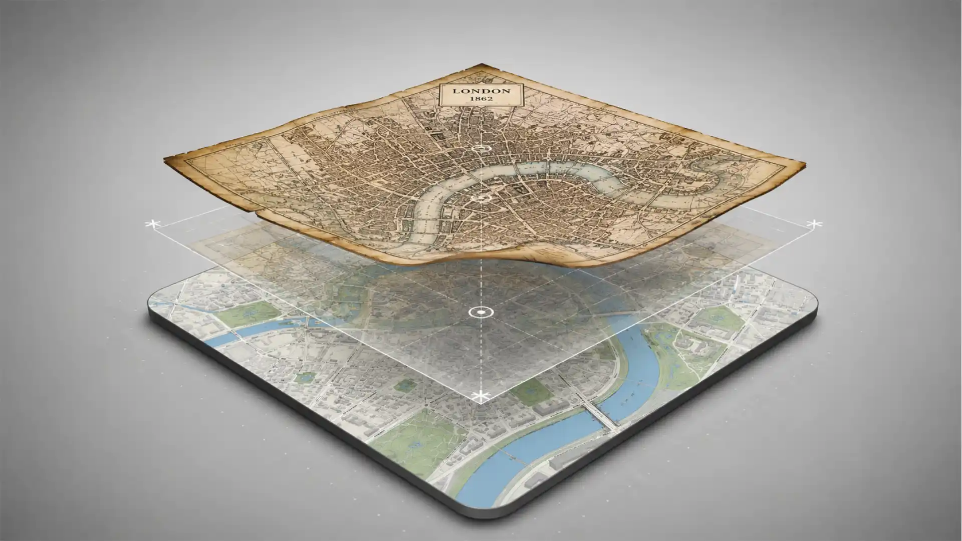
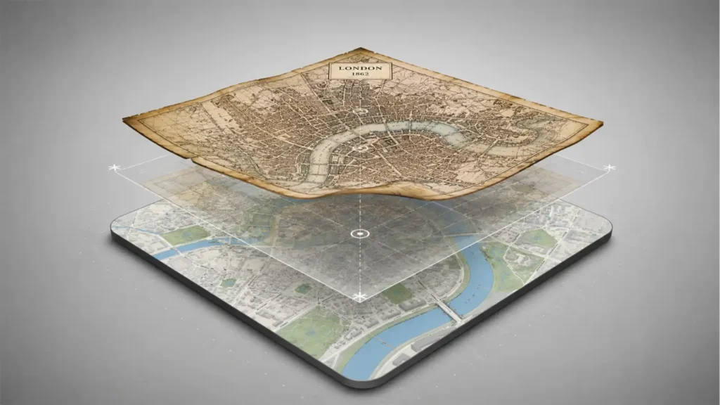
The seductive part of Old Maps Online is the overlay: an old map aligned with current geography so you can compare past and present without doing the mental gymnastics yourself. The serious work sits underneath that apparent magic. A historic scan does not arrive ready to sit over a modern basemap. It has to be positioned, matched, checked, and sometimes revised. A hand-drawn or printed map may be warped by the paper, distorted by the original survey, incomplete at the edges, or made according to a projection that does not line up neatly with today’s coordinate systems.
The word for the process is georeferencing. It sounds more technical than it feels once you see it in action. You identify points visible in both the historic image and contemporary geography—a street corner, bridge, church, island edge, coast, crossing, or other landmark—and use them to bind the scan to a real location. The more carefully that relationship is established, the more useful the image becomes for search, comparison, and analysis. It stops being only a digitised object and starts behaving like a document with a location. Old Maps Online’s own material describes this as turning scanned maps into geographically searchable documents.
That shift may sound modest, yet it changes how an archive can be used. A title is a weak way to find a map. Titles can be vague, old spellings can confuse search, and catalogue descriptions often assume you already know the geography. A map that says “Plan of the Environs” is almost useless in a conventional keyword search until you know whose environs it means. A map tied to coordinates becomes discoverable through the ground it depicts. You no longer need to guess the archive’s language before you are allowed to find its image.
The project’s Georeferencer service makes that process visible as a public activity rather than a closed technical operation. Institutions can use it to assign location data, improve metadata, and invite the public to participate in locating scanned maps. The platform includes review mechanisms, contribution tracking, and ways to present progress. That is a smart answer to a very archival problem. Libraries have objects and expertise, but not always enough staff hours to manually connect every scan to the map of the world. Enthusiasts often have local knowledge, patience, and a strange pleasure in matching a coastline or road network to its modern counterpart.
Crowdsourcing gets praised too easily, usually as a cheerful story about people donating spare time. Here, it works because the task has a real intellectual reward. Georeferencing is a puzzle with consequences. You are not merely clicking through a survey. You are identifying the points where an old visual system still touches the current world. You find a river mouth, a station, an island, a line of hills, a street corner that escaped redevelopment. Each match is a claim that can be checked. Each completed map becomes easier for someone else to discover through place rather than archival chance.
The process also produces a useful kind of humility. Old maps do not always want to behave. A neat city plan may align beautifully. A regional map may resist because the cartographer simplified distance or shape. A map of a battlefield may be accurate where the action mattered and loose at the periphery. A coastline may be recognisable but transformed by reclamation, dredging, erosion, harbour works, or different surveying practices. There is no universal “correct overlay” that makes every historical map a perfect mirror of the present. The goal is not to erase the object’s age. It is to make its relationship to place legible.
That distinction matters because the aesthetic success of an overlay can deceive. A map fitted to the current world is still a historical argument. Its boundaries may be political claims rather than neutral facts. Its labels may preserve colonial language, older ethnonyms, administrative categories, or the omissions of a governing power. Its blank areas may signal missing information, but they may also signal disregard. Digital positioning makes a map easier to use; it does not make the map unbiased. Old Maps Online is compelling partly because the modern basemap keeps that tension in view. You can see where the old image agrees with the world and where it insists on an older way of seeing it.
The project makes room for institutions too. Its Georeferencer pages describe geographic search applications for individual collections, exports for GIS and catalogue systems, and support for standards such as WMTS and IIIF. That is the infrastructural side of the romance. The charming public experience rests on decisions about image delivery, metadata, record keeping, formats, and interoperability. Few casual users need to think about those layers. Yet they are why a fragile scan can become a document that libraries, researchers, developers, and local-history obsessives can all use in different ways.
It is tempting to treat this as a story about technology rescuing dusty materials. The reality is more interesting and less flattering. The maps were never inert. They already carried rich spatial information; the digital work makes that information easier to find and compare. The rescue narrative gives too much credit to software and not enough to the people who surveyed, printed, stored, catalogued, conserved, digitised, and described the material before anyone matched it to a modern coordinate system. Old Maps Online sits at the end of a long chain of care, not at the beginning.
That chain is worth remembering when a result carries you to another institution’s viewer. The site is a gateway, not a universal owner. Its map previews point back to providers, and the source collection remains part of the encounter. This is a good design choice. It means the portal gets to act like a broad discovery layer without pretending that every record came from one seamless archive. The source institution may offer a higher-resolution image, richer catalogue notes, related sheets, download options, rights information, or a whole collection that deserves its own visit.
The moment you understand that structure, Old Maps Online becomes more than a place to browse. It becomes a map of map archives. The site is showing you historical geography, yes, but it is also quietly showing you where the world’s cartographic memory lives. Scotland, the United States, Czech lands, London, New York, Zurich, Bern, Dresden, Utrecht, and many other places appear through the institutions that chose to make material discoverable in this shared way. The website does not flatten those collections into a single nameless warehouse. It lets them remain distinct while making them easier to encounter.
That feels like an older, better version of the web. Discovery leads outward instead of trapping you inside one platform. You find something through a common interface, then follow the trail toward the archive that holds it. The click does not finish the experience; it begins a more specific one. At a time when many services want to own every second of attention, that outward impulse is almost quaint. It is also exactly right for cultural material that has provenance, context, and custodians worth knowing.
Search built for curiosity rather than cataloguers
Search engines are usually good at rewarding a precise request. You know the phrase, the item, the person, the address, the product, the answer. Old Maps Online is more useful when your request begins half-formed. You may know the town but not the old district name. You may remember that a relative lived near a mill, but not which mill. You may want to see the world around a fort, harbour, border, station, battlefield, or industrial estate without having a particular sheet in mind. The site’s strongest move is to let geography carry the search when language fails.
A map-first search interface changes the rhythm of inquiry. You browse by territory rather than by title. That sounds obvious, yet it is a sharp departure from how many digital collections work. Search boxes are ruthless with uncertainty. Enter the wrong spelling, the old name, a translated name, a local nickname, or a vague description, and the catalogue may shrug. A location on a map is more forgiving. It allows you to approach a historical object through the area it covers, which is often the only part you actually know.
The user experience has a practical intelligence. You can move around the world map, zoom into a place, and look for available historical material. Timeline controls introduce a second dimension without making the screen feel like a specialist instrument panel. The dates encourage exploration rather than compliance. You are not filing a formal request for “all maps from 1873.” You are testing a hunch: what was this region like before the railway, before the new border, before the reservoir, before the town broke out of its old walls, before the district acquired the name people now use as if it had always existed?
That is also why the project gets away with being educational without feeling like homework. It uses the reader’s own geography as the lesson plan. People will learn about political boundaries, surveying, urban growth, military history, land use, and the fragility of place names because they are trying to understand their own corner of the map. This works better than starting with a generic historical overview because a place gives the abstraction a physical address. You can see what a border does when it runs through settlements. You can see what urban expansion does when former fields become a street pattern.
Old Maps Online has been expanding the historical side of its interface too. A 2025 update described a unified search for battles, regions, rulers, notable people, and place names, with results brought together rather than split into separate search paths. This pushes the project beyond map retrieval. The map becomes a way into historical context, not only a surface to inspect. Search a figure or event and you may be drawn toward the locations and territorial changes around it. Search a place and you may find the human history that made its boundaries or name intelligible.
There is a risk in adding context to a map archive. It can become a noisy layer of trivia that pulls attention away from the objects. Old Maps Online avoids the worst version of that problem by keeping place at the centre. The historical material is there to deepen a location, not to turn the site into an endless feed of facts. The map remains the stage. Events, people, and regions matter because they occurred somewhere, changed something somewhere, or shaped the authority under which a location was drawn.
The most rewarding searches often follow a pattern. Start broad, then get stubborn. Look at your city. Notice one old road or boundary. Search the name. Check nearby maps from different dates. Follow the provider link. Search the old name in a local archive or newspaper collection. Return to Old Maps Online with a more precise point. The site is good at being the first move in that sequence because it gives you a visible clue before it demands a vocabulary. It rewards curiosity with a direction.
It also rewards a certain tolerance for ambiguity. The map may not settle your question cleanly. A name can shift locations. A route can be marked differently by different mapmakers. A village can become a suburb, a suburb can be absorbed into a city, and a border can make older labels feel politically loaded or geographically misleading. The site does not erase these contradictions. It lets you compare them. That is a more honest form of discovery than a neat answer card pretending that history has one stable spelling and one stable outline.
The visual side matters here. Search results that contain maps carry more atmosphere than search results that contain documents. A title may be dry. A thumbnail can pull you in immediately. You notice the density of a city plan, the sweep of a coastline, the strange colour scheme of a thematic map, the handwriting on a manuscript sheet, the ornate edges of an atlas plate, the utilitarian grid of a military survey. These are not decorative bonuses. They signal different relationships to territory. The map’s style hints at what kind of question it was made to answer.
There is no shortage of historical map websites. Some are better for a specific country, collection, type of map, or technical comparison. Old Maps Online’s value is its first-contact quality. It is the place you visit when you do not yet know which archive should own your question. The portal gives you a way to test whether a place has a cartographic trail at all. When it does, you can follow that trail toward deeper, more specialised sources. When it does not, the absence itself tells you to change your approach.
The site’s own language compares the portal to “Google for old maps,” and the comparison works only up to a point. Google is built to reduce searching to a result. Old Maps Online is better when it turns searching into a habit of looking. The answer is rarely one page. It is an overlap, a before-and-after, a strange old label, a road that does not survive, a collection you did not know existed. The web is full of services that want you to finish quickly. This one improves when you linger.
That lingering has a quiet civic value. It makes local knowledge feel less small. A person who knows a footpath, an estate boundary, a family farm, a disused siding, a minor bridge, or a district’s stubborn old name has something to bring to the map. They may not have a formal historical education, but they understand clues that matter. Old Maps Online does not turn everyone into a professional researcher. It gives ordinary familiarity a way to become curiosity with evidence behind it.
The archive is much bigger than the interface
The phrase “historical maps” can make a project sound narrower than it is. It brings to mind yellowed atlases, decorative coastlines, antique globes, and the sort of image used behind a vintage-themed café menu. Old Maps Online contains that pleasure, but its real territory is broader and stranger. Search long enough and you run into town plans, military sheets, cadastral records, survey drawings, transportation maps, nautical charts, thematic diagrams, regional overviews, colonial claims, property documents, and sheets made for purposes that have little to do with nostalgia.
A map is often where an institution admits what it cared about. The content reveals priorities in a way prose can hide. A cadastral plan cares about plots, ownership, and taxable land. A military map cares about movement, elevation, crossings, and defensible terrain. A railway map cares about connection and commerce. A colonial map cares about possession, extraction, routes, and authority. A tourist map cares about attention and desire. A town plan cares about streets and buildings, but also about what has been made legible to an administrator. Old Maps Online gives these objects a shared entry point without making their motives identical.
The partner network makes that diversity concrete. The site lists material from institutions such as the National Library of Scotland, the USGS Historical Topographic Map collection, the David Rumsey Map Collection, the British Library, the New York Public Library, and archives and libraries across Europe and beyond. That range is not merely a boast about coverage. It means a single place may surface through several mapping traditions: local survey, national topography, military planning, private collecting, colonial administration, or municipal record keeping. Each one may describe the same ground differently because each one needed the ground for a different purpose.
The National Library of Scotland collection alone is a good example of why the site feels generous. Its indexed material includes a huge run of Scottish maps, much of it detailed topographic mapping from the nineteenth and twentieth centuries, alongside town plans and bathymetric charts. A place with dense coverage becomes a time series rather than a souvenir. You can move through editions and watch the built world spread, industrial features appear or vanish, coastlines get engineered, and place names shift in confidence and spelling. The old map stops being one old map. It becomes a stack of evidence.
The USGS material produces a different mood. Topographic sheets train your eye to see terrain as structure. You begin to notice contours, watercourses, roads, settlements, and the stubborn relationship between infrastructure and ground. Even when a town changes dramatically, the ridge line does not care. Streams may be culverted, railways removed, and suburbs expanded, but the slope still dictates awkward road layouts and the positions of older crossings. Compare enough topographic maps with current views and you develop a mild suspicion that the land gets the final say more often than planners admit.
The David Rumsey collection brings another type of pleasure: cartography as an image culture. Its material includes rare maps and a global spread of historical cartographic objects, many of them visually ambitious. Here, the map can be a factual document, a statement of national identity, a work of ornament, an educational device, or a strikingly personal attempt to make the world intelligible. Old Maps Online’s project pages noted in 2024 that more than 8,000 digitised Rumsey maps were available for georeferencing, a reminder that even widely known collections still contain work waiting to become easier to discover by location.
The British Library material offers another useful contrast. Its linked collections include Ordnance Surveyors’ Drawings from the first detailed survey of Britain and the Crace Collection of London maps. The scale of attention changes the kind of truth you get. A broad national map gives you a sweeping narrative. A detailed survey drawing gives you the awkward local texture: paths, parcels, bends, buildings, edge conditions, and the small decisions that disappear when a place is later reduced to a simple street grid. You begin to understand why large archives are not only repositories of “facts.” They preserve different levels of attention.
No portal can make all this material equally easy to read. The interface is an invitation, not a guarantee of perfect access. Some maps are clear at first glance. Others demand patience. Some records carry dates, scale, and author information that feel immediately useful. Others offer a sparse title and an uncertain date range. Some scans are crisp enough to reward close viewing. Others are limited by the condition of the original or the available digitisation. That is not a failure of the concept. It is a reminder that digitisation does not turn archival material into frictionless content.
The friction is often where the object asserts itself. A difficult map makes you slow down. You may need to inspect the legend, understand the sheet’s purpose, or accept that a visual comparison will only get you so far. Modern interfaces have trained us to expect instant legibility. Old maps were made for readers with different habits, local knowledge, professional training, or political assumptions. Meeting them halfway is part of the encounter. You are not just consuming an image. You are learning the rules by which someone else organised the world.
There is also a useful ethical pressure in viewing historical maps through a current interface. The past becomes present enough to interrogate. A disputed border is not a decorative line when you can see it placed over contemporary territory. A colonial name is not a quaint label when it sits where current communities live. A military road is not abstract when it aligns with homes, farms, or landscapes still shaped by conflict. Old Maps Online does not provide a complete interpretive framework for every hard case, and it should not pretend to. It gives you the visual proximity that makes the questions harder to avoid.
The website’s scale also makes it a kind of antidote to the image-first web. These maps demand context, not just appreciation. It is easy to share a beautiful old chart as texture. It is harder, and more rewarding, to ask what it was for, who produced it, what it leaves out, and how its view of the world became materially consequential. Old Maps Online gives you the chance to begin with beauty and end with a more serious reading. That is a much better use for digital access than turning archives into decorative wallpaper.
For the curious visitor, the practical advice is simple: do not browse only for the prettiest map. Open the dry-looking sheet. Follow the provider link. Compare editions. Look at the date, scale, and coverage. Check whether the map is a survey, a plan, a chart, or an atlas plate. Notice the vocabulary. The unexpected material often carries the strongest local revelations. A theatrical world map may delight you. A boring-looking survey sheet may explain why your neighbourhood exists in its current shape.
TimeMap gives the map a second clock
Old Maps Online already had a strong premise: search old maps through modern geography. The newer TimeMap layer changes the feeling of the site by adding a second kind of movement. You are no longer only comparing an archival scan with the present. You are moving through historical regions, borders, and places across time. The map becomes less like a cabinet of old sheets and more like an interface for testing how political and cultural frames changed around a location.
This matters because maps are often used as if they were frozen answers. TimeMap puts time back inside the map itself. A city is not merely a dot. It has sat inside different kingdoms, empires, states, provinces, cultural zones, and administrative arrangements. A border is not just a line; it is a line that arrived, moved, hardened, dissolved, returned, or became irrelevant to a particular period. A place name may carry several historical lives. The timeline makes that instability visible without requiring you to read a long chronology before you are allowed to explore.
In March 2026, Old Maps Online added a Places layer to TimeMap, bringing clickable cities and settlements into a view already concerned with historical regions and borders. Users can click a location, examine its historical context, and move the time slider to see surrounding political and territorial conditions change. This is a clever addition because it makes large history local again. A shifting empire is easy to ignore when it is a coloured area on a continent. It becomes more intelligible when you see what it meant for a specific city you can name and locate.
The site is not the first project to show historical borders, and it does not need to be. Its advantage lies in the connection between time, place, and archival maps. A user can become interested in a historical region through the timeline, then look for scanned maps that cover a point within it. Or they can start with an old map and use TimeMap to understand the political context surrounding it. The two modes of discovery strengthen each other. One tells you what the paper shows. The other suggests the changing territorial story in which the paper was made.
There is a danger in historical boundary maps: colour can make power look too clean. Empires do not live on the ground as tidy polygons. Borders are contested, porous, unevenly enforced, and experienced differently by different people. A time slider can create an illusion of neat succession if the viewer forgets that every change came with argument, administration, violence, negotiation, migration, or daily confusion. TimeMap is most interesting when you use it as a prompt for further inquiry rather than a final authority. The visual clarity should make you ask more questions, not fewer.
Even so, the ability to scrub through a timeline is compelling. It gives change a physical rhythm. You watch regions expand, contract, break apart, and rename themselves. You see a city remain while the political frame around it changes repeatedly. You notice how long certain arrangements lasted and how brief others were. A line that feels permanent in current affairs can look suddenly young. A border treated as natural can reveal itself as an event with a date. The map does not settle the politics of any territory, but it does make permanence look less convincing.
TimeMap works best when it remains attached to the real messiness of place. Use it with a city you know or a place you have just found in an old map. Pick a point, not an empire. Watch what changes around it. Then return to a historical sheet from that period and look at the labels, routes, and nearby settlements. You will notice how a formal political map and a lived local map tell different stories. One tells you which colour governed the area. The other may tell you which road people used, where water lay, what was cultivated, and which village mattered enough to print.
The website’s recent “On This Day” feature sits in the same family of ideas. It links daily historical moments—events, battles, territorial changes, rulers—to maps and locations. This could easily have become a novelty calendar. In the best use case, it is a nudge toward spatial thinking. History often arrives as a date and a name. Put it on a map and the question changes: what did this event look like from nearby towns, routes, ports, river crossings, or frontiers? Where did it happen, and what did it alter in physical terms?
The larger point is that historical maps become more inviting when they stop asking users to begin with a document. TimeMap lets the user begin with an intuition about time. What was this place called then? Which state was it part of? Why does this local boundary feel strange? What did the surrounding region look like before a familiar political arrangement existed? Those questions are not always precise enough for an archive catalogue, but they are perfect for a map interface that treats chronology as something you can touch.
There is a distinct pleasure in watching a known city drift through political categories. The city becomes more stable than the state around it. Buildings change, populations change, languages and institutions change, yet the point on the map keeps asking to be understood. That inversion is valuable. National stories often give the impression that territory is the main character. TimeMap makes it easier to see that people lived in settlements and landscapes before, during, and after the colours around them changed.
This does not mean the map replaces history. A visual timeline is a doorway, not a verdict. It can show sequence, proximity, and territorial relationship. It cannot on its own explain the lived realities behind each transition. That work belongs to sources, scholarship, local memory, and the contested interpretations that historical events deserve. Old Maps Online is strongest when it embraces that limited role: it helps you see where to look and what changed around a place, then leaves room for the harder work of understanding why.
Before you start hunting for your own corner
The people who will get the most from Old Maps Online are not a neat demographic. They are people with a place in their head. A family historian has an address from an old document. A runner notices that a trail follows an inexplicable curve. A novelist wants the real road layout of a fictionalised town. A designer is tired of using antique maps as generic texture and wants to understand their actual purpose. A student wants to see the geography behind a historical event. A local resident has lived beside a “new” development long enough to suspect it has an older story.
The easiest way to use the site badly is to treat it like a search engine you must master before it gives anything back. Use it more casually at first. Search your home town. Search a place you visit often. Move around the map without a grand mission. Choose a period that interests you. Open an image even if you are unsure why it is there. The first session is for learning what kinds of material exist. Precision can arrive later, once a label, route, collection, or old district name gives you something sharper to pursue.
A productive session has a loose shape. Begin with recognition, then follow the first anomaly. Find something current that anchors you: a river, church, coast, road, rail line, ridge, or market square. Scan the old map until it appears. Then stop looking for the obvious. Look for what is missing, duplicated, rerouted, oddly named, or surrounded by empty space. The anomaly is usually the thread. It may lead you to a vanished feature, a different boundary, a former use of land, or a mapmaking convention that forces you to learn more.
Do not be afraid to use the site for small questions. Small questions produce better discoveries than grand ones. Why is that street called Mill Lane when there is no mill? Why does the park boundary look like a bite taken out of the block? Why is the school on a road that seems too wide? Why does the village high street curve around an invisible centre? Why is a footpath aligned with the back gardens of modern houses? You may not find every answer, but the map often gives you a more interesting question than the one you started with.
There is also no shame in using Old Maps Online for pure visual pleasure. Some maps are good company. They are dense, odd, decorative, technical, delicate, overconfident, and full of choices that a current basemap has sanded away. Spend time with the lettering. Look at the treatment of water. Notice where the paper had to fold, where a margin carries a note, where a cartographer made a mountain or coastline into a graphic performance. The site does not need to justify that enjoyment with an educational outcome. Attention is already a form of use.
The caution is simple. Do not mistake an old map for a transparent window. Date matters. Scale matters. Purpose matters. Who made it matters. The absence of a place name does not prove the place did not exist. The presence of a border does not prove everyone treated that border as settled. The accuracy of a road does not guarantee the accuracy of everything around it. Historical maps are superb sources, but they are sources with authors, patrons, limits, and interests. The best browsing experience keeps that suspicion alive without letting it kill the pleasure.
Questions worth settling before you disappear into the map
The public portal is open to browsing, searching by place, and following map records to participating institutions. Access to the underlying material can vary by provider, because Old Maps Online is a discovery layer built from archival and library collections rather than one locked box of identical records. Some source sites offer generous viewers and downloads; others may have their own conditions, tools, or limits. That outward link is a feature, not a detour, because it keeps the holding institution and its record visible.
In many cases, yes: georeferenced maps can be aligned with current mapping so users can compare the past and present at the same location. The accuracy depends on the map’s original survey, condition, scale, and the quality of the georeferencing work. Treat the overlay as a powerful guide to spatial change, not as a courtroom-grade measurement device for every historical feature. The closer you look, the more the map’s own age and purpose will matter.
Use a place you know well enough to recognise a few anchors. A childhood neighbourhood, a village centre, a railway station, a local river, or a family address works better than a famous landmark. Familiarity gives the comparison force. Find a current feature, locate it on the old sheet, then notice what appears around it. Once you have one old name, route, or landmark, the next search becomes much easier and more personal.
Yes. The project invites participants to help locate and georeference maps by aligning historic scans with modern geography. The contribution is real archival work in miniature. Public participation does not replace institutional knowledge, but it expands what collections can make searchable and reviewable. The project also presents community routes for adding maps and supporting open georeferencing efforts. People who know a region closely may be better at recognising a local clue than someone working from a distant catalogue.
That is the wrong contest. Old Maps Online is often the best place to start, not the only place to finish. A specialised local portal may have deeper coverage, better scans, richer notes, or stronger tools for one area. A national archive may offer material that has not yet surfaced in a shared index. Use Old Maps Online to discover what exists, identify collections, and build a trail. Then go deeper wherever the evidence takes you.
Historical mapping follows money, administration, military needs, transport, ownership, and institutional survival. Uneven coverage is part of the historical record. Major cities, strategic regions, colonised territories, industrial areas, and well-funded survey systems may leave a thick trail. Other places appear only in broad sheets, at the edges of someone else’s map, or not at all in a given collection. A thin result set does not mean a place lacks history. It means the surviving and digitised cartographic record is incomplete.
Old Maps Online will not replace a local historian, a specialist map archive, or the slow work of reading a place through many sources. It does something less grand and, in practice, more useful. It gives the internet a proper front door to historical geography. You arrive with a point on the current world, and the site gives you permission to suspect that point has been many things before it became your ordinary route, your address, your view from the train, or the unnamed patch of ground you never expected to care about.
The web is full of systems that promise access to everything and leave you with less curiosity than you began with. Old Maps Online does the opposite. It gives you a finite square of ground and makes it feel crowded with prior versions. The old map is not a novelty layer over reality. It is proof that reality has always been layered. Start with the street you know best. The odds are good that the past is still there, under your feet, waiting for the right scale of map.
Author:
Jan Bielik
CEO & Founder of Webiano Digital & Marketing Agency
This article is an original analysis supported by the sources cited below
OldMapsOnline
The public portal’s overview of historical map discovery through location and timeline browsing.
OldMapsOnline partner collections
The portal’s current partner list, indexed-map count, and descriptions of participating archival collections.
OldMapsOnline Georeferencer
Official explanation of geographic search, map georeferencing, community contribution, review, and standards support.
Explore Historical Places with TimeMap
Official account of TimeMap’s Places layer, clickable settlements, historical regions, and timeline controls.
Smarter and Simpler History Search
Official description of the updated unified history search across places, regions, people, rulers, and events.
David Rumsey maps ready for georeferencing
Official announcement describing how scanned maps are connected to real-world locations and made geographically searchable.