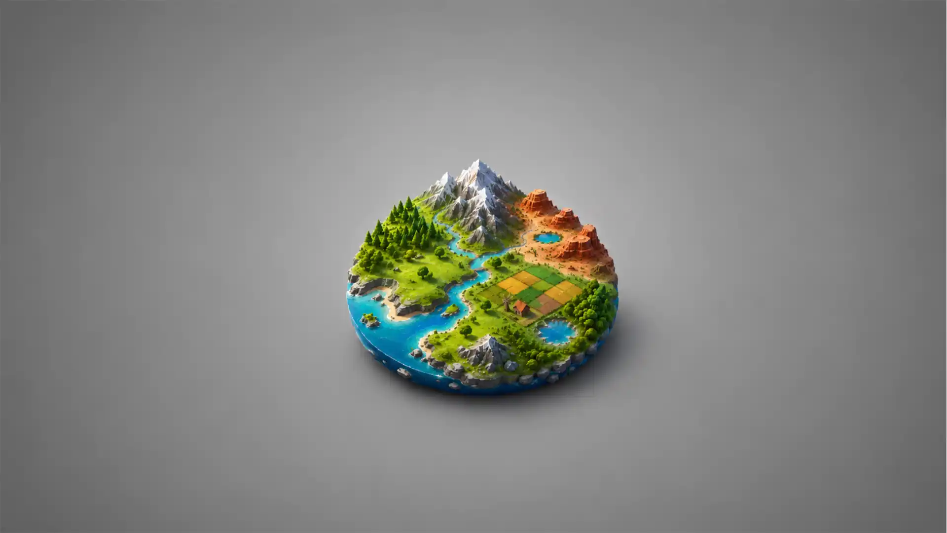
Terraink starts with a quiet little trick: type a place, wait a moment, and the streets stop behaving like directions. They become texture. Rivers become negative space. Parks become patches of relief. A familiar city suddenly looks less like something you commute through and more like something you might frame. That shift is why the site is worth opening. It does not ask you to become a cartographer. It asks you to notice that your neighborhood already has a shape.
Table of Contents
The tool calls itself “the cartographic poster engine”, and for once the phrase fits without much strain. Terraink is a free map poster and wallpaper creator for any city or location, with exports for PNG, PDF, and SVG according to its public site listing. Its GitHub repository describes custom city map posters powered by OpenStreetMap data, with geocoding, themes, layers, typography controls, and high-resolution export.
What makes Terraink interesting is not only that it produces attractive maps. Plenty of tools make attractive maps if you accept their presets and stop asking questions. Terraink feels more like a compact design instrument. You can change themes, tune layers, adjust labels, pick layouts, place markers, and treat the map as an image with a point of view rather than as a utility meant to get you from one street to another.
It also arrives at a good moment for web discovery. The internet is full of giant platforms that hide small useful things under search-engine sludge. Terraink is the opposite kind of object: a narrow tool, made with care, easy to describe, useful within seconds, and slightly addictive because it turns every place name into a design prompt. You start with your city. Then the place you grew up. Then the town where someone you love lives. Then some island, border, port, old trip, or fictional-feeling place you once zoomed into on a map at 1 a.m.
The appeal sits in that loop. Terraink gives you a reason to search for places emotionally, not logistically. Most digital maps answer practical questions: where is this, how far is it, which route is fastest, what is nearby. Terraink turns the map inside out. It cares less about navigation and more about composition. The streets are still real. The data still comes from the collaborative mapping world. But the output is closer to a poster, a lock-screen image, a gift, a memory, or a quiet brag about where you are from.
A map poster engine with fewer wrong turns
Terraink’s first strength is that it understands what people actually want from a map poster generator. They do not want a GIS lesson. They do not want to register an account before seeing whether the tool has taste. They do not want to fight a layout system built for professionals. They want to search a place, get a map with real street geometry, nudge the appearance, and export something clean enough to share or print.
The official Android listing says Terraink lets users create customizable map posters for any location, control style, colors, labels, and layout, add markers, and export designs for printing or sharing. It also says the app needs no account and was updated on May 3, 2026, with mobile availability. That matters because the tool does not feel like a demo trapped in a browser tab. It has already moved into the phone-shaped use case where many people collect screenshots, wallpapers, travel memories, and quick visual ideas.
The web version is the cleaner discovery moment. A good small web app should reward impatience. Terraink does. You arrive, search a location, and the map starts doing the thing. There is no long onboarding tunnel. No fake productivity language. No gallery wall of “premium templates” blocking the actual tool. The page has a plain promise: create a map poster or wallpaper, then export it.
That directness would not mean much if the maps looked generic. Terraink’s output has a crisp graphic character rather than the washed-out look of a normal map screenshot. Roads can become linework. Water can become a strong block of color. Parks, buildings, and boundaries can either appear as supporting detail or get pulled back until the road network becomes the whole image. It treats cartographic data like a visual material.
The GitHub README lists the underlying mapping stack: OpenStreetMap contributors for map data, OpenMapTiles for tiles, OpenFreeMap for tile hosting, Nominatim for geocoding, and MapLibre for rendering. That stack explains why the project feels web-native rather than like a closed poster shop. It sits on public mapping infrastructure and open-source browser rendering, then wraps those parts in a design interface.
There is a small cultural pleasure in that. A global, volunteer-shaped map database becomes a personal object in your room. OpenStreetMap is often discussed as infrastructure: data, license, edits, imports, coverage, routing, humanitarian use. Terraink reminds you that the same data also has emotional weight. The street where your school was, the bridge you crossed every day, the tangle of roads around your apartment: all of it has a pattern.
That pattern is more personal than a satellite image. Satellite imagery shows place as surface, but street geometry shows place as habit. A map poster of a city is not a picture of rooftops. It is a picture of decisions: grids, dead ends, rivers, old roads, new bypasses, parks that interrupted construction, hills that bent streets sideways, political borders that made towns face away from each other. Terraink does not explain all of that, which is part of its charm. It just lets the structure show.
The strongest poster tools know when to remove information. A navigation map is measured by how quickly it answers a question; a poster map is measured by what it leaves behind. Terraink is most pleasing when you strip it down. Remove the clutter, keep the streets, sharpen the contrast, let the city’s skeleton sit in the frame. Some places become delicate. Some become dense. Some become strangely empty because the interesting shape is in the water or terrain edge rather than the road network.
The site’s name also has a nice accidental ambiguity. Terraink sounds like terrain plus ink, which is exactly the product’s promise. The public materials sometimes use Terraink and sometimes TerraInk, and the Google Play copy even contains a typo-like “Terraoink” line. That could look messy in a larger brand. Here it reads more like a young tool still being shaped in public. The core identity is clear enough: inked maps made from terrain and streets.
Terraink is not the first project to make map posters, and it does not need to pretend otherwise. Its own repository credits MapToPoster by Ankur Gupta as inspiration while describing Terraink as an independent reimplementation built from scratch with Bun, React, and TypeScript. That acknowledgement is healthy. The internet is better when small tools reveal their lineage instead of pretending every interface arrived by lightning strike.
The difference is in how much control Terraink places near the surface. A poster generator lives or dies by the tiny decisions between “good enough” and “I would actually use this.” A few more layout choices, a better color palette, a cleaner export, a marker placed at the right spot, a font that does not ruin the image: these are not decoration. They are the difference between a toy and a tool people keep returning to.
Why it feels better than a template shop
Most map poster products fall into a familiar pattern. They sell a finished object before they let you feel the joy of making it. You pick a city, choose a frame size, maybe change the color, and the system routes you toward checkout. That model works for gifts, but it turns the map into merchandise too quickly. Terraink’s charm is that the making comes first.
The difference is subtle but real. Terraink behaves like a browser-based sketchbook for places. You are not only selecting a product. You are trying versions. You can search, rotate, zoom, switch themes, change the crop, remove layers, bring a label back, decide the river matters, decide it does not, and export only when the image feels right. Even when the interface is doing a practical job, the emotional loop feels creative.
That loop has a low barrier. The search box is the invitation. A person who knows nothing about maps still knows a place name. That is enough. Search for Bratislava, Nairobi, Medellín, Osaka, Halifax, Bergen, or the town where you spent one weird summer, and the tool gives you a base composition. From there, the controls speak in visual terms: style, label, layout, layer, marker, export.
Terraink’s GitHub feature list mentions smart geocoding, including search by city or region name and manual coordinate entry. That pairing is more thoughtful than it first appears. Casual users search names. Map nerds and designers may want exact coordinates. A person making a poster for a cabin, trailhead, small island, venue, cemetery, or childhood house may need precision beyond city search. Terraink does not force one path.
The layout choices push it beyond a quick screenshot machine. Spatialists, a geospatial news site, noted more than twenty layouts, including paper sizes and social-media image formats, plus custom layout creation. That is the kind of feature that looks ordinary until you try to use a poster generator for something specific. A desktop wallpaper, Instagram image, A3 print, phone lock screen, and square post all want different framing. A city that looks elegant in a tall poster may look cramped in a square crop.
The theme system is the most obvious delight. Color changes the meaning of a map faster than almost any other setting. A black background with pale streets makes a city look cinematic. A cream background with dark linework makes it feel like a print pulled from an archive. A bright palette turns the same data into something closer to digital art. Terraink’s README describes dozens of curated themes and custom color palettes, while outside reviewers also noticed its breadth of color choices.
Good map colors are harder than they look. A street network contains thousands of tiny marks fighting for attention. If every layer shouts, the poster becomes mud. If every layer whispers, the image goes limp. Terraink’s better themes understand contrast: roads need clarity, water needs calm or drama, parks need restraint, text needs enough presence to anchor the piece without becoming the piece.
The tool also avoids a common sin of map design apps: it does not treat labels as an afterthought. The repository lists typography controls for city and country display labels, plus the ability to load Google Fonts families. That matters because one bad font can make a graceful map feel like a tourist kiosk print. Type is the difference between “custom poster” and “screenshot with a title.”
Markers are where Terraink becomes personal instead of merely pretty. A map poster of Paris is generic until you mark the apartment, the station, the restaurant, the hospital, the stadium, or the corner where something happened. The Android listing mentions markers and personal touches, and the README includes marker support as part of the tool’s feature set. Markers turn a city map into a memory map.
They also widen the audience. A designer may use Terraink for visual studies, but a normal person may use it for a birthday, moving announcement, travel souvenir, wedding location, farewell gift, or desktop background. The tool sits between design and sentiment. That is a useful place to be. It gives map people enough control to respect the data, while giving everyone else a way to make something that feels attached to a real place.
A German geo blog tested Terraink by making a Halle map, adding a marker, exporting a PNG, and using the result as a Teams background. The same post describes the workflow as entering a location, setting theme, layout, and styles, then enriching the map with markers, layers, and routes, using OpenStreetMap data. That Teams-background detail is small but revealing. Tools like this rarely stay inside their intended category. A poster generator becomes a wallpaper generator, a meeting background maker, a social image tool, a local-pride toy, and a quick way to make a place feel designed.
What stands out at a glance
| Feature | Why it matters |
|---|---|
| Search by place or coordinates | Works for both casual names and precise spots |
| Theme and color controls | Turns street data into a designed object |
| Layer toggles | Lets the map become simple or detailed |
| Markers | Makes a generic city feel personal |
| PNG, PDF, and SVG export | Supports print, sharing, and further editing |
| Open-source code | Keeps the project inspectable and forkable |
| Android version | Moves poster-making into a phone workflow |
The compact version is this: Terraink earns attention because it treats map design as a set of small choices rather than a checkout page with a preview image. The table also shows why the project is harder to dismiss as a novelty. It has enough control to support tinkering, yet the first use is still simple.
The export story is especially important. A pretty preview is not enough if the downloaded file looks bad. Terraink’s public site listing mentions PNG, PDF, and SVG exports, while the README specifically calls out high-resolution PNG export at defined dimensions. SVG matters because it opens the door to editing in design software. PDF matters for print workflows. PNG matters for everything else.
The browser-based nature gives Terraink a second advantage. There is no heavy creative suite between the user and the output. A designer might still bring the exported file into Illustrator, Figma, Affinity Designer, or Inkscape later. But the first pass happens in the browser, where the stakes feel low. That makes experimentation painless. You do not plan a poster; you poke at a city until it looks right.
The Android app makes the idea less desk-bound. People discover places on phones, save memories on phones, and share images from phones. The Google Play listing reports 1K+ downloads and places Terraink in the Art & Design category, with no account required. Small numbers are not a weakness here. They make the project feel early enough to be discovered, not already flattened into a mainstream utility.
Terraink also benefits from an interface category people understand instantly. A map poster needs no explanation. The moment someone sees it, they know whether they want to search their hometown. That is a rare strength. Many clever web tools require a paragraph before the user knows what to do. Terraink’s hook is visual and personal: show me my place as art.
The small product choices that make the maps feel personal
A tool like Terraink does not need hundreds of features. It needs the right few controls in the right emotional order. Search first, because place is the seed. Then crop and layout, because the poster must have a frame. Then themes and layers, because the map needs taste. Then labels and markers, because the user wants ownership. Then export, because the work should leave the browser.
The order matters because map data is overwhelming. Cities are dense with things nobody wants on a poster. Street classes, paths, railways, water edges, buildings, green space, neighborhoods, labels, icons, boundaries, points of interest: a normal map needs all of that because people need to navigate. A poster needs hierarchy. Terraink’s layer controls let the user decide how much of the world survives into the image.
Spatialists noted that users can toggle elements on or off and choose from seven OSM layers. That is the kind of control that makes the tool feel respectful. It does not assume every place should be treated the same way. Some cities are all roads. Some are defined by coastline. Some need water. Some need parks. Some become more interesting when buildings appear as texture. Others look cleaner when buildings disappear.
A good map poster also needs a sense of scale. Zoom too far out and the city becomes a blot; zoom too far in and the pattern loses identity. Terraink’s manual coordinate and framing controls give users a way to decide what the poster is really about. Is it a whole city? A neighborhood? A route? A river bend? A port? A university district? A place where two grids collide?
The strongest outputs often come from places with visual tension. Cities with rivers, bays, hills, old centers, ring roads, coastlines, canals, bridges, or broken grids produce richer posters. Terraink makes that visible quickly. You do not need to read an urban history to see that Amsterdam, Istanbul, Venice, Cairo, Manhattan, Tokyo, or Lisbon has a different graphic rhythm from a flat suburban grid. The map tells you.
The danger is that some places are too plain at first glance. A grid can look boring until the right crop makes it hypnotic. Terraink’s rotation and framing controls, described in its YouTube launch material and visible in product descriptions, matter because they rescue places from obvious framing. A city does not have to be centered like a passport photo. It can sit diagonally, drift to one side, or let a river cut through the composition.
Personal markers change the story again. A red dot on a poster is not just a design element; it is a claim that this place matters. That is why marker customization matters more than it might seem. If all markers look like default pins from a delivery app, the poster loses its mood. When markers can be adjusted, uploaded, resized, or recolored, the user gets a little authorship back.
The official materials mention custom markers, including different colors and sizes and uploaded PNG or SVG files in the YouTube description surfaced by search. That pushes Terraink toward small storytelling. A couple could mark where they met. A runner could mark race points. A family could mark homes across a city. A creator could mark venues, shops, galleries, campuses, or favorite corners. The map becomes a clean stage for private geography.
There is a whole genre waiting there. People do not only want maps of famous places; they want proof that ordinary places have shape. The cul-de-sac town, the industrial district, the village beside a river, the suburb cut by a highway, the campus where every path has a memory: these places rarely get design attention. Terraink gives them a poster treatment without asking whether they are famous enough.
The tool also invites comparison. Search two cities and you start noticing personality in road networks. Some places look nervous, all short streets and sharp turns. Some look bureaucratic, all grids and blocks. Some look improvised. Some look like geography won every argument with planning. Some have rings, spines, fragments, scars. Terraink turns this into a casual visual habit.
That casual habit is part of the magic. The site is not only a poster maker; it is a way to browse the world by pattern. A person can spend fifteen minutes searching places they know, places they miss, and places they have never visited. The reward is not a route or a restaurant. It is a composition. That makes Terraink feel closer to a map-based toy than a normal productivity tool, and that is a compliment.
The poster format also removes the anxiety of correctness. Nobody expects a wall map to be a perfect navigation product. It should be accurate enough to respect the place, but its main job is visual. That gives Terraink room to make choices. A park might be simplified. A tiny alley may become linework. Labels may be reduced. The output is a designed interpretation made from real data.
OpenStreetMap is the quiet star here. Terraink depends on the fact that thousands of mapped places already exist in editable public data. OpenStreetMap’s copyright page describes its data as available under the Open Database License, with required attribution to OpenStreetMap contributors. Terraink is one more reminder that open geodata does not only feed routing engines and analysis dashboards. It feeds art tools, too.
That brings responsibility. A map poster is only as good as the data underneath it. In cities with rich OpenStreetMap coverage, Terraink has a lot to draw from. In places where mapping is thinner, the output may feel sparse or uneven. That is not a Terraink-specific flaw. It is the nature of public map data. The tool makes coverage visible in a way that normal map apps sometimes hide.
The project’s use of MapLibre also fits the open-web character. MapLibre GL JS is an open-source map rendering library that grew from the need for an open vector-map renderer. Terraink’s repository lists MapLibre as its renderer, and MapLibre’s own site presents the project as open-source mapping software. For users, that detail may be invisible. For the web, it matters. It means the pretty poster is not sitting entirely on a closed black box.
The result feels like a web app from the older, better internet: one person or a small project scratching a specific itch, publishing it, and letting other people play. It is not a massive platform. It is not trying to become your creative operating system. It is a specific tool with a specific pleasure. That clarity makes it easier to trust.
What Terraink gets right and where it still feels young
Terraink gets the first minute right. That is the minute most web tools lose. The promise is easy to understand. The output appears quickly. The controls are not buried under a business-model lecture. The reward is visual. You do not need to watch a tutorial before deciding whether it is for you.
It also gets the “one more search” loop right. The tool turns curiosity into a repeatable action. Search a place, see its pattern, change the style, export or move on. That loop is strong because it is both practical and playful. You might be making something for print, or you might just be satisfying the itch to see whether your hometown has a good-looking street skeleton.
The design controls are deeper than the average casual user expects. Themes, typography, layouts, markers, and layers give the tool enough depth without making it feel like professional GIS software. This is a difficult balance. Too few controls and the output looks like a template. Too many controls and the casual user leaves. Terraink leans toward control, but it does not lose the simple premise.
The export formats are another strength. SVG export is the feature that makes designers take a second look. A PNG is great for wallpapers and quick sharing. A PDF makes sense for print. SVG means the map can become raw material for later editing. The public site listing names PNG, PDF, and SVG exports, while the Reddit build-in-public post around version 0.3.0 also described SVG and 300 dpi export as part of an update.
Terraink also seems to understand that map posters travel socially. A poster of a place is shareable because it invites people to respond with their own place. A LinkedIn post from Milan Janosov, for example, described Terraink as worth a look and invited people to share their road networks in the comments. That is exactly the kind of sharing loop a tool like this wants. The content is personal, but the format is easy to copy.
The project is still young, and you can feel it. The naming inconsistency between Terraink and TerraInk, the small copy issues in listings, and the still-in-development note in the README all give it a slightly unfinished edge. The GitHub README says feedback and community contributions are welcome, and the roadmap lists unfinished work around discoverability, code quality, export options, marker improvements, a theme gallery, and accessibility auditing. That edge is not fatal. It is part of the current texture.
The biggest product question is not whether Terraink works. It is whether the tool can stay simple while becoming more capable. The roadmap already points toward features that could make the app richer: more export controls, better marker features, theme previews, and accessibility work. Each addition is sensible. Each also risks adding weight to a tool whose charm comes from speed and clarity.
A theme gallery, for example, sounds useful. But a gallery should not turn Terraink into a template marketplace. The best version would make themes easier to discover without pushing users into preset dependency. A theme should be a starting point, not a cage. Terraink’s current appeal comes from the feeling that you are shaping the image yourself.
Marker improvements also need restraint. Bulk imports, custom icons, and richer marker tools could serve real users, but too much annotation would push the poster toward infographic territory. That may be fine for some use cases. A travel map, event map, or project map may need many points. But Terraink’s most elegant outputs often have fewer things on them. The product should protect the beauty of less.
Accessibility is a serious roadmap item because map tools often forget keyboard and screen-reader users. A visual poster generator will always be image-centered, but the controls still need to be reachable, labeled, and predictable. The roadmap explicitly lists a full keyboard navigation and screen reader audit across features. That is good to see in a small creative tool. Accessibility should not arrive only after a product becomes large.
The self-hosting story is another technical strength with a catch. The README includes Docker deployment instructions and local development commands, which makes Terraink more inspectable than a closed web service. For most users, this will not matter. For developers, civic-tech people, map enthusiasts, schools, and small organizations, it matters a lot. A local or modified deployment opens possibilities beyond the hosted app.
The catch is licensing and branding. The repository says new changes from April 3, 2026 are AGPL-3.0, while older code remains under MIT, and it adds trademark protections around the Terraink name. That is a normal tension for a young open-source product: share the code, protect the identity, keep hosted-service confusion under control. Anyone forking it should read the license and trademark notes instead of assuming “open source” means “use the name however you like.”
The Google Play privacy box adds one more detail worth reading carefully. The listing says the app may share location data with third parties, says no data is collected, and says data is encrypted in transit. That combination likely reflects how map and geocoding services work, but users who care about location privacy should pay attention. Map tools often need location or place queries to function. The cleaner question is what gets stored, by whom, and for how long.
The official YouTube description surfaced in search says the application is free, open-source, privacy-first, and runs entirely on the client side with no data sent to servers. That is a strong claim, and it fits the project’s identity. Still, the safest editorial reading is this: Terraink is built with a privacy-conscious posture, but the app also relies on mapping and geocoding infrastructure, so users should treat precise location searches with the same care they would bring to any map app.
A young product also has to decide whether it wants to monetize. Free creative tools gain goodwill quickly, then discover that hosting, support, updates, and user expectations are not free. A Reddit thread around version 0.3.0 includes the creator discussing the possibility of a small ad because the tool is free to use and is taking more time to maintain. That kind of build-in-public honesty is refreshing, but ads would change the mood if handled badly.
The best path would protect the core: fast access, no forced account, generous exports, and a clear free tier that does not punish casual use. Donations, business licensing, hosted-service extras, or paid high-volume features would fit the project better than an ad layer that makes the canvas feel cheap. The README already mentions Terraink Business and a business contact for hosted access with more features and support. That sounds more aligned with the tool’s personality.
There is also a branding opportunity hiding in the roughness. Terraink should lean into being the small serious tool for map posters, not a generic “AI design” or “creator platform” product. Its advantage is specificity. The web does not need another vague design suite. It needs more sharp tools that do one thing with taste.
The project’s social presence suggests it knows this. Its YouTube channel description calls TerraInk a free, open-source, client-side cartographic poster engine. The phrasing is not polished to death, which is fine. The stronger move is visual proof: examples of cities, neighborhoods, islands, ports, and weird grids that make people immediately search their own place.
The open web story under the pretty poster
Terraink is easy to like as a design toy, but the more interesting story is what it reveals about the open web’s raw material. The map is not a private asset locked inside one company’s design product. It is made from open data, open rendering tools, public tile infrastructure, and code that people can inspect. The poster is the visible surface of a larger ecosystem.
That ecosystem is not abstract. OpenStreetMap contributors map roads, paths, buildings, parks, water, and countless local details, then projects like Terraink turn that work into new experiences. The value here is not only civic or technical. It is aesthetic. Open data gives small creators enough raw material to build tools that would have been unrealistic for a solo project not long ago.
The OpenStreetMap link also changes how the user sees the output. A Terraink poster is not a proprietary illustration of a city; it is an interpretation of a shared map. That means attribution matters. It also means the quality of the poster is connected to community mapping labor. If your place looks sparse, the answer may not be “the tool failed.” The answer may be that the map needs more local detail.
This gives Terraink a subtle educational role. It makes people notice mapped data without turning them into students. Someone who has never edited OpenStreetMap may still start wondering why one neighborhood has building footprints and another does not. They may notice missing paths, strange road classifications, or oddly named places. A poster generator can become an accidental doorway into mapping literacy.
The rendering stack matters because maps are hard. Drawing vector maps in a browser at interactive speed takes specialized tools, not just a canvas and hope. Terraink uses MapLibre according to its README, which helps explain the live-rendering feel. The user experiences it as dragging, styling, and exporting. Underneath, there is a serious map renderer doing careful work.
OpenFreeMap and OpenMapTiles sit in the same story. Terraink’s README names OpenMapTiles for tiles and OpenFreeMap for tile hosting. Those names will not mean much to a casual poster maker, but they matter to anyone who cares about how small tools survive without massive mapping contracts. The web needs layers of shared infrastructure so creators can build useful things without asking permission from one dominant provider.
The client-side claim is also part of this character. When a creative tool runs mostly in the browser, it feels lighter and less extractive. You are not uploading a personal location scrapbook into a platform account just to produce an image. You are shaping the map locally, at least by the project’s own stated posture. That is a better fit for a tool built around personal geography.
There is a trade-off. Client-side tools can struggle with persistence, heavy exports, and project saving if they avoid server accounts. A Reddit discussion around version 0.3.0 includes the creator noting that, because the app is entirely client-side, saved settings and posters would likely be stored locally, with import/export planned. That answer reveals a real product philosophy: less server dependency, more local control, but some conveniences become harder.
That philosophy is worth protecting. Many web tools start with instant access and then slowly add account walls, cloud projects, dashboards, teams, upsells, and usage meters until the original joy is gone. Terraink’s best future is not to become a heavy platform. It is to become a sharper, more durable version of itself: quick to open, precise enough for serious use, generous enough for casual play.
The map-poster category has room for that. People buy framed maps because places carry emotional status. A birthplace, university town, first apartment neighborhood, marathon route, wedding city, migration path, or ancestral village all carry a charge. Terraink lowers the cost of turning that charge into an image. You do not have to order a print. You can make the file, keep it, share it, or print it yourself.
That do-it-yourself angle changes the relationship. The user is not only a customer choosing from a catalog; the user becomes a tiny art director for a place they know. That role is satisfying. It gives people enough agency to feel the result is theirs, while still leaning on real map data so the image is grounded.
Terraink also makes a case for narrow creativity tools. A tool does not need to generate everything to be memorable. It only needs a strong object and a fast path to that object. Terraink’s object is clear: a custom map poster. That clarity is why it is better than many larger tools that bury their best feature under a hundred unrelated buttons.
There is a lesson here for product makers. The best small web apps often start from a tiny sentence that makes people act. “Turn any place into a poster” is one of those sentences. It is specific, visual, personal, and testable in a minute. The user does not need to imagine the benefit. They type a place and see it.
The design world sometimes undervalues that immediacy. A lot of tools talk about creative freedom while forcing users through heavy setup. Terraink gives freedom through a small frame. A map, a palette, a layout, a few toggles, an export. The frame is what makes the freedom usable.
The project’s GitHub popularity also signals something. At the time I checked, the repository showed thousands of stars and hundreds of forks, which is strong attention for a niche map-art tool. Stars are an imperfect signal. They do not prove daily use. But they do show that developers, designers, and map people recognize something worth saving.
The same applies to blog mentions. Spatialists recommended Terraink for unique maps for print or social media, while geoObserver tested it as a DIY poster and wallpaper maker using OpenStreetMap data. Those are the right kinds of external signals: not hype from a generic launch site, but people in or near the geospatial world noticing the craft.
The strongest Web Radar finds are often tools that make the web feel handmade again. Terraink has that quality. It is specific enough to feel made by someone who wanted the thing to exist, not by a committee chasing a market category. It has edges. It has public code. It has a young roadmap. It has small copy imperfections. It has an immediately satisfying object. That combination makes it memorable.
The people who should open it first
Designers should open Terraink because it gives them map texture without forcing a full cartography workflow. Need a background for a poster, a local campaign image, a mockup, a social asset, a presentation cover, or a visual study of a city grid? Terraink gets you there faster than building a map style from scratch. The SVG export makes it especially useful when the output needs later editing.
Map people should open it because it is a friendly public face for OpenStreetMap data. Not every OSM-based tool needs to be a routing app, editor, humanitarian dashboard, or developer library. Some should simply make the data beautiful. Terraink does that in a way people understand instantly. It might even nudge a few users toward noticing and improving local map coverage.
Travelers and sentimental internet users should open it because the tool turns place attachment into an image without becoming cheesy. A poster of “the city where we met” can easily slide into gift-shop territory. Terraink avoids that when the user chooses restraint: clean lines, a quiet label, one marker, strong crop. The result feels personal without screaming.
Remote workers and students should open it because it makes quick wallpapers and video-call backgrounds from places that matter. The geoObserver test using a Terraink PNG as a Teams background is a perfect example of an accidental use case. A map background is more interesting than another blurred room and less cringe than a branded virtual office.
Local businesses and cultural groups should look carefully, too. A café, gallery, running club, neighborhood association, bike shop, school, hostel, festival, or small museum could use a tasteful local map image without commissioning custom cartography. The open-source nature may matter here, especially if a group wants to self-host or adapt the tool. The trademark rules still need respect, but the code being available changes the conversation.
People making gifts may be the largest natural audience. A place-based gift has a built-in story. The map of a hometown, proposal spot, first trip, adopted city, or family village does not need much explanation. Terraink gives people a way to make that gift less generic. The danger is overdesigning it. The best gift maps will probably use fewer labels, a softer palette, and one meaningful marker.
Urbanists and planners may enjoy Terraink for a different reason. It reveals street-network personality at a glance. The tool is not an analytical platform, and it should not be mistaken for one. But it is a good visual prompt. Comparing grids, cul-de-sac suburbs, radial cities, waterfronts, and historic cores can spark real observations. Sometimes a poster view is enough to make a planning pattern obvious.
Teachers could use it as a gentle classroom tool. Students often understand place better when they see the shape rather than the address. A class could compare their town with another city, look at how rivers or highways cut through neighborhoods, or make posters of places connected to literature, migration, history, or geography. The tool’s no-account posture helps here, though educators would still need to check school policies and privacy rules.
Developers should open the repository because Terraink is a readable example of a focused creative web app built around map rendering. The README lists Bun, Vite, React, TypeScript, MapLibre, Docker deployment, and contribution rules. It is not only a product to use; it is a project to study, fork responsibly, or learn from.
The people least likely to enjoy Terraink are those expecting full professional cartographic control. If you need advanced GIS analysis, data joins, projections, publication cartography, data cleaning, or exact map-generalization rules, this is not the tool. Terraink is a poster engine. Its job is visual making, not spatial analysis. That boundary is healthy.
The same goes for people expecting a polished commercial print service. Terraink gives you files, not a framed object arriving at your door. That is a feature for people who want control and a limitation for people who want convenience. You handle printing, paper, frame, and color checks yourself. For many users, that trade is worth it. For gift buyers in a hurry, a full poster shop may still win.
Terraink is best when the user brings a place with emotional charge and enough patience to try a few versions. The first output may look good, but the third or fourth usually feels like yours. Change the crop. Remove a layer. Try a calmer theme. Turn the label off. Add one marker. Rotate the city slightly. Export. That small craft process is the product.
The kind of small tool the web still needs
Terraink is not important because it will replace design software or mapping platforms. It matters because it makes a specific kind of creative act easy enough to become casual. You can turn a real place into a clean poster without a subscription, a design degree, or a cartography workflow. That is a small promise, but it is a good one.
The best thing about Terraink is that it respects the emotional pull of geography without smothering it in sentimentality. It does not ask you to write a story about the place. It lets the streets do the talking. If the place matters to you, the pattern carries the feeling. If it does not, the poster may still look good, but it will not have the same charge.
There is a quiet editorial taste in that restraint. The tool trusts linework, contrast, space, and place names. It does not need fake paper textures, inspirational quotes, or heavy decorative frames. The map is enough. That confidence separates it from many personalization products that cover weak design with emotional clichés.
Terraink also understands a truth about maps: they are already abstractions, which means they are already halfway to art. A road map is not the world. It is a chosen set of marks. Change the colors, remove navigation clutter, crop carefully, and the abstraction becomes obvious. Terraink gives ordinary users a way to feel that transformation.
The project’s open-source posture makes the tool more interesting than a polished closed alternative would be. You can inspect the repo, see the stack, read the roadmap, and understand the attribution chain. That transparency fits a tool built from open mapping data. It also makes the imperfections more forgivable. The project feels alive rather than packaged.
Still, Terraink should be careful as it grows. The quickest way to ruin a tool like this is to add too much product around the core interaction. Accounts, galleries, social feeds, template stores, prompt boxes, watermark games, pop-ups, and cramped monetization could all weaken the thing people came for. The core should stay almost boring: search, style, frame, mark, export.
A better growth path would deepen quality rather than widen purpose. Sharper exports, clearer theme previews, better local project saving, stronger accessibility, cleaner mobile polish, and thoughtful marker handling would all fit the product. The roadmap already points in that direction. The trick is to make those features feel like craftsmanship, not bloat.
Terraink also has room to build culture around examples. A gallery of great city crops could teach users without turning into a template trap. Show why a river crop works. Show how a coastal town changes when rotated. Show how building footprints affect density. Show how one marker can be stronger than ten. Good examples would make users better at seeing maps.
The tool could also lean harder into local pride. People love seeing their place treated as worthy of design. Big cities get endless posters. Small towns, border regions, overlooked suburbs, and ordinary neighborhoods rarely do. Terraink’s global search makes those places available. That is not a minor thing. It democratizes the “this place deserves a poster” feeling.
The map community may find a promotional angle here. Beautiful outputs from OSM data give contributors a visible reward. Editing a map can feel abstract. Seeing a local area become a clean poster is tangible. Terraink could become a soft bridge between casual users and the mapping community if it handles attribution and education well.
There is also a deeper reason the tool sticks in the mind. Digital maps have become so practical that we forget they are strange. We pinch, route, scroll, and obey the blue dot. Terraink slows the map down. It removes the instruction layer and leaves the shape. Suddenly the city is not telling you where to go. It is letting you look.
That is the Web Radar reason to recommend it. Terraink gives you a tiny new behavior on the internet: searching places just to see their graphic soul. That is enough. Not every web discovery needs to solve a painful problem. Some should make a familiar object feel fresh again.
Small doubts worth clearing up
Cost and access
Terraink is presented as free to use, with open-source code available on GitHub. The official repository describes the project as open source, and outside geospatial coverage also calls it free and open-source. The README also mentions Terraink Business for hosted access with more features and support, so the project may develop a split between free public use, open code, and business-oriented support.
Accounts and mobile use
The Android listing says no account is required, and the web app also presents itself as a direct creator rather than an account-first product. The Google Play page lists Terraink under Art & Design, says it is available on mobile, and describes poster design from the device. For a tool built around quick experiments, that no-account posture is part of the appeal.
Print readiness
Terraink is built around export rather than print fulfillment. The public site listing mentions PNG, PDF, and SVG export, while the README mentions high-resolution PNG at defined dimensions. That means users should still think like print buyers: check size, resolution, margins, paper, and color before paying for a large physical print.
Privacy and location
Terraink’s own public materials present the project as privacy-conscious and client-side, but map search still touches mapping infrastructure. The Google Play listing says the app may share location data with third parties while collecting no data, and its app description says no account is needed. Anyone making a poster from a sensitive private location should use the same caution they would use with any digital map tool.
Open-source reuse
The code is public, but the name and branding have rules. The README says new changes from April 3, 2026 are AGPL-3.0 and older code remains under MIT, while the trademark document restricts use of the Terraink name and logo in ways that imply endorsement or confuse users. Developers should read the license and trademark files before publishing a fork or hosted derivative.
Best first thing to try
Search a place you know too well. Not a famous capital, not a postcard city, not somewhere chosen because it will look impressive. Use the town you grew up in, the neighborhood you left, the city you moved to, or the route you associate with someone. Terraink is strongest when the map is not only nice, but yours.
Author:
Jan Bielik
CEO & Founder of Webiano Digital & Marketing Agency

This article is an original analysis supported by the sources cited below
Terraink
Official web app for creating map posters and wallpapers from locations, including the public product promise and export formats.
Terraink GitHub repository
Official source repository with features, mapping stack, licensing notes, self-hosting instructions, attribution, and project background.
Terraink on Google Play
Official Android listing with mobile app description, feature summary, update date, download range, no-account claim, and data-safety details.
Spatialists post about Terraink
Geospatial news write-up describing Terraink’s customization options, layouts, layers, markers, creator information, and open-source status.
geoObserver article about TerraInk
Hands-on German blog post testing Terraink as a DIY poster and wallpaper maker using OpenStreetMap data.
OpenStreetMap copyright and license page
Official attribution and licensing reference for OpenStreetMap data used by Terraink’s mapping stack.
MapLibre
Official site for the open-source map rendering project listed in Terraink’s technical stack.
| Citing this article? Brief excerpts are welcome. Please credit Webiano.digital, name the author where stated, and include a link to https://webiano.digital and to this original article. Full or substantial republication requires prior written permission. Read our Copyright and Content Use Policy. |