
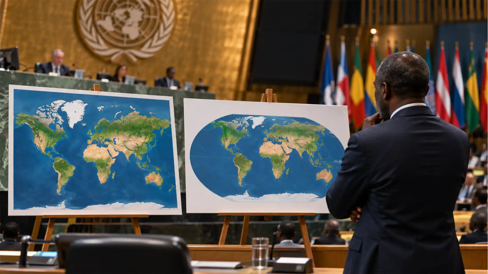
Resolution A/80/L.104 passed on 4 September with only the United States opposed, urging schools, governments and technology firms to show continents at true relative size. The arithmetic behind it is sound and the diplomacy was patient. The awkward part is that the companies rendering most of the world’s maps take their cues from tile geometry and national naming databases rather than from the General Assembly.
The General Assembly adopted draft resolution A/80/L.104 on Friday 4 September by 164 votes to one. The United States stood alone against it. Estonia, Georgia, Lithuania, the Republic of Moldova, Serbia and Ukraine abstained. Togo facilitated the text on behalf of the African Group, with the Bahamas and France among the co-sponsors, and it encourages governments, schools, international organisations and technology companies to use equal-area projections such as Equal Earth wherever the comparative size of continents matters.
The underlying arithmetic is not contested by anyone. Africa covers roughly 30.3 million square kilometres. Greenland covers about 2.17 million. On a Mercator world map the two look comparable, which is a factor-of-fourteen error sitting in plain sight in a great many classrooms.
The resolution carries no obligation, no deadline and no reporting requirement. It leaves two audiences. Education ministries answer to governments and can act on it within a budget cycle. The handful of firms that render the maps most people actually look at answer to no one at the United Nations. Days before the vote, two of those firms changed the printed name of a Great Lake for American users after a White House order. That contrast, rather than the margin, is the thing worth reading closely.
Inside the text that 164 states approved
The measure was taken under agenda item 13, on follow-up to major United Nations conferences, and its operative language is hortatory throughout. It encourages rather than requires, and the UN’s own account of the vote is explicit that it neither bans Mercator nor imposes a replacement. What it does ask is narrower and more interesting than the headlines suggested: use equal-area projections where relative size matters, and teach that no flat map can reproduce a sphere without giving something up.
That last clause matters because the resolution concedes the point sceptics usually lead with. Every projection sacrifices area, shape, distance or direction. Equal Earth keeps area and pays for it in shape, most visibly at the edges. The text does not pretend otherwise.
The framing around that technical core is what drew fire. The resolution describes correcting cartographic distortion as an act of “cognitive justice and memorial reparation” and says the Mercator projection has contributed to the “symbolic minimization” of Africa. Robert Dussey, Togo’s foreign minister, put the case more plainly before the vote, saying maps guide education and shape collective perceptions, and afterwards that a fair map changes how the world is seen rather than what the world is.
Togo’s foreign ministry also closed off the objection cartographers raise first. Its statement said the resolution in no way challenges the use of Mercator for maritime and aerial navigation, where the projection remains entirely suited to the job it was designed for in 1569. A rhumb line drawn straight on a Mercator chart is still a constant compass bearing, and nothing in the resolution touches that.
A petition from 2025 that reached the General Assembly floor
The route to the plenary ran through advocacy rather than diplomacy for most of its length. Africa No Filter and Speak Up Africa launched the Correct the Map campaign in 2025, asking governments, media, schools and international organisations to adopt Equal Earth, and built it around a public petition and direct approaches to institutions. The campaign has said it sent a request to UN-GGIM, the UN’s geospatial coordination body.
The African Union endorsed the campaign on 14 August 2025. Selma Malika Haddadi, deputy chairperson of the AU Commission, told Reuters that the Mercator map created a false impression that Africa was marginal, and framed the endorsement as part of reclaiming Africa’s standing at a moment of wider argument over colonial-era reparations. Moky Makura of Africa No Filter called the projection the world’s longest-running misinformation campaign, a formulation that is rhetorically strong and empirically shaky.
The campaign’s own theory of change was never about the United Nations. Fara Ndiaye of Speak Up Africa told Reuters the group was working to make Equal Earth the standard across African classrooms, and the campaign’s public demands name schools, newsrooms, businesses and digital platforms rather than diplomatic fora. The General Assembly was a way of putting a stamp on that request, not the mechanism for delivering it.
Twelve months later the same argument arrived in New York with a state sponsor and a text. France moved first among the co-sponsors: hours before the vote, Foreign Minister Jean-Noël Barrot announced at the Sorbonne that the French foreign ministry would abandon Mercator in favour of representations more faithful to actual surface areas, arguing that the United States, Russia and China take on disproportionate visual prominence and that distortions eventually take root in perceptions.
The concession embedded in that announcement is worth naming. On an equal-area map France shrinks, as do the United States and Russia. Equal-area projections do not enlarge Africa; they remove the enlargement Mercator grants everything closer to the poles. Dussey has told Reuters he hopes to change Togo’s own school geography materials by the end of the year and will press other governments, schools, international organisations and technology companies to follow.
The geometry that makes Greenland swell
Gerardus Mercator’s 1569 construction solved a navigational problem by preserving angles. The cost of conformality is fixed by the mathematics rather than chosen by the cartographer: the scale factor grows as the secant of latitude. At 45 degrees linear scale is about 1.41 times true, so area is roughly doubled. At 60 degrees linear scale is exactly twice true and area is quadrupled. The further from the equator, the worse it gets, until the poles cannot be drawn at all.
Africa straddles the equator and is therefore drawn close to true scale. Greenland sits between roughly 60 and 83 degrees north and is inflated several times over. The two end up looking similar in a way that has nothing to do with intent and everything to do with the secant function.
Equal Earth was built to offer an alternative that schools would actually hang on a wall. Bojan Šavrič of Esri, Tom Patterson of the US National Park Service and Bernhard Jenny of Monash University published it in the International Journal of Geographical Information Science in 2018. It is an equal-area pseudocylindrical projection, visually modelled on the widely liked Robinson but, unlike Robinson, rigorously area-preserving. Its creators have been open that they designed it as a more visually acceptable substitute for Gall–Peters, which some schools and campaigning organisations had adopted on fairness grounds despite its severe shape distortion. NASA’s Goddard Institute for Space Studies picked it up quickly, and it is implemented in PROJ and Esri’s software, so the switching cost for a static global graphic is close to zero.
The trade-off does not vanish. Equal Earth stretches shapes near the map’s outer edges and its poles are drawn as lines rather than points. It is a good general-purpose world map and a poor navigation chart, which is the inverse of Mercator and precisely the point.
Web Mercator as a tiling standard rather than a worldview
The projection in almost every phone is not quite Mercator. It is Web Mercator, catalogued as EPSG:3857, introduced by Google Maps in 2005 and adopted by Bing, Apple, Mapbox and OpenStreetMap. It applies spherical Mercator formulas to a sphere with the radius of the WGS 84 semi-major axis, ignoring the ellipsoid’s flattening, and it truncates the map short of the poles so the world forms a square that can be recursively quartered into tiles.
That square is the whole design. Slippy maps work because each zoom level divides the previous one into four aligned tiles, which makes caching, prefetching and address arithmetic trivial. Conformality does the rest: at street zoom a roundabout stays round, a right-angled junction stays right-angled, and a north arrow points the same way everywhere on screen. Swapping in an equal-area projection would break all of it, because equal-area projections shear local shapes and vary in orientation across the frame.
Sarah Battersby and colleagues at the US Geological Survey set out the paradox in Cartographica in 2014. Mercator had been effectively retired from general-purpose global print maps by the cartographic community, then returned through the back door of web mapping and became dominant there without much resistance. The projection people object to in the classroom won a second life as an engineering convenience.
This is why the resolution’s request to technology companies is the hardest of its asks and the least likely to be met soon. Google made a partial move in 2018, showing a three-dimensional globe in the desktop global view, though Reuters reported in 2025 that Mercator remained the default on the mobile app. Static maps are a styling decision. Tiled basemaps are an architecture.
Control over the default map sits outside the General Assembly
A useful test of who actually decides what a map shows arrived in the same week as the vote. On 27 August, a US executive order directed the Interior Department to rename Lake Ontario as Lake America in the Geographic Names Information System, part of an escalating tariff dispute with Canada. Google Maps applied the change for US users over the following weekend, citing its long-standing practice of following official national naming sources. Apple followed at the start of September, after Interior Secretary Doug Burgum said the president had contacted the company directly. MapQuest refused, offered users a tool to rename the lake themselves, and rose to the top of the App Store in both countries.
Set that beside the resolution. One instrument produced compliance from the largest consumer mapping product in roughly forty-eight hours and from the second within five days. The other produced a 164-to-1 endorsement and no compliance obligation at all. The difference is not political will but the presence of a legal hook into a data pipeline the platforms already ingest.
Naming works this way because platforms have chosen to treat national gazetteers as authoritative inputs rather than editorial decisions. Google’s stated policy is to follow the official naming system of the country whose users are being served, which is why the same lake now carries three different labels depending on where the phone is. That rule is defensible, cheap to administer and shifts responsibility onto governments. It also means any state with a naming authority holds a lever over the world’s most-used maps, and the General Assembly holds none.
Projection has no equivalent lever. There is no register of approved projections, no legal instrument that ingests one, and no jurisdiction in which displaying Mercator is non-compliant. Attempts to create one would run straight into the objection the resolution itself concedes, that different projections suit different purposes. The result is that the most persuasive argument in cartography arrives without any of the plumbing that makes a far weaker argument about a lake name effective within a weekend.
Instruments that change what a world map shows
| Instrument | Binding force | Observed response | Reach |
|---|---|---|---|
| UNGA resolution A/80/L.104 | none, hortatory | France announced a ministry-level switch | 193 states, voluntary |
| US executive order via GNIS | binding on federal agencies | Google and Apple within days | US users of two platforms |
| National curriculum decisions | binding on state schools | Togo targeting end of 2026 | one country at a time |
| Institutional style policy | internal only | World Bank phasing Mercator out | that body’s own output |
| Platform product roadmap | none, commercial | 2018 desktop globe, mobile unchanged | billions of daily users |
The rows with real compliance share a feature the resolution lacks: a chain of command or a database the target already reads. Persuasion occupies the top row alone, which is where most of the world’s map users sit.
Institutions that moved before the vote and the classroom that has not
One quiet fact reframes the whole exercise. The United Nations Secretariat was never the problem. Its geospatial service states that it prescribes no single projection and that the majority of its world maps use Robinson, Winkel III or Eckert IV, all compromise projections chosen to limit polar exaggeration. The UN emblem itself is an azimuthal equidistant projection centred on the North Pole, extending only to 60 degrees south and omitting Antarctica entirely, a choice made in 1946 and never framed as an injustice to anyone.
Other institutions had already moved. A World Bank spokesperson said in 2025 that it uses Winkel Tripel or Equal Earth for static maps and is phasing Mercator out of its web maps. National Geographic left rectangular world maps behind decades ago. Among the bodies the campaign named, the practical work was substantially done before the General Assembly weighed in.
That leaves schools and consumer platforms as the only targets where the resolution can plausibly change what people see. Of the two, schools are cheaper, faster and entirely within the reach of the governments that just voted. A wall map is a procurement decision. A textbook diagram is a re-export from software that already supports Equal Earth. Togo’s end-of-year target for its geography materials is a real test precisely because it is small enough to be achieved and specific enough to be checked.
The harder question is whether other African Union members follow with published curriculum standards rather than statements of support, and whether ministries outside the continent treat the resolution as anything more than a press release. Nothing in the text obliges them to, and nothing in the vote count tells us how many intend to.
Sovereignty caveats and the six abstentions nobody expected
The abstention list looks strange until the explanations are read. Estonia, Georgia, Lithuania, Moldova, Serbia and Ukraine are not defending Mercator. Every one of them has a live or recent dispute about how its own territory is drawn.
Ukraine said it supported correcting historical distortions affecting Africa and the Global South, then objected to the way some maps published using Equal Earth depict Ukrainian territory occupied by Russia. Its representative warned that endorsing a projection without safeguards could open a “Pandora’s box” of cartographic ambiguity over disputed territories. That is a narrow, technical objection to a specific set of published maps rather than to the projection’s mathematics, and it is the reason the abstentions cluster the way they do.
The European Union voted in favour and inoculated itself in writing. Speaking for the bloc, Ireland’s explanation of vote recorded that the resolution’s scope is strictly limited to cartographic representation for educational, awareness-raising and geographical literacy purposes, including the depiction of the relative size of continental landmasses. It states that the measure neither addresses nor affects sovereignty, territorial status, delimitation or internationally recognised borders anywhere, and adds that EU support does not constitute endorsement of the equal-earth.com website or the maps it hosts. Boundary representation within the UN system remains governed by the references prepared by the UN Geospatial Information Section.
The American objection ran in the opposite direction and targeted the preamble rather than the projection. Washington’s representative called the initiative part of a larger radical ideological project, singled out the references to reparations and cognitive justice, and described such measures as barnacles on the institution’s work. A separate US line dismissed the text as superfluous. Both are arguments about the framing, and neither disputes the secant function.
Cognitive evidence thinner than the resolution’s preamble
The resolution rests on a causal claim: sustained exposure to Mercator has shrunk Africa in the world’s mental picture. That claim is more contested in the research literature than the diplomatic language admits, and honest advocacy is better served by knowing it.
The largest test to date is Lieselot Lapon, Kristien Ooms and Philippe De Maeyer’s worldwide study in the ISPRS International Journal of Geo-Information in 2020, which analysed 970,820 area estimates from 97,082 participants. Their estimates correlated more strongly with true areas, at 0.807, than with Mercator-projected areas, at 0.636. Continents presented in Mercator were estimated slightly more accurately than the same continents presented in equal-area Gall–Peters. Europe was heavily overestimated, and Africa was not underestimated at all. The authors found no quantitative evidence for a Mercator effect on area perception. Daniel Montello and Sarah Battersby reached a compatible conclusion in the Annals of the American Association of Geographers in 2022, reporting that the effect they could detect showed up in direction judgments rather than recalled areas.
That is a serious problem for the preamble and not for the policy. The same 2020 study found that populations most familiar with Robinson estimated sizes significantly more accurately than populations most familiar with Mercator, and its authors concluded that media and educational materials should use less area-distorted projections. The defensible version of the case is simply that a general-purpose world map should not misstate area by a factor of four, and that a map used to teach comparative geography should be an equal-area map. That argument needs no claim about damaged mental maps, and it survives every study cited above.
The null findings deserve their own caution. That 2020 sample was self-selected through social media, roughly seven in ten participants were men and four in five held a higher qualification, which is not a population from which absence of an effect can be safely generalised to schoolchildren. What the evidence supports is that the causal claim is unproven rather than refuted, and unproven claims make poor foundations for treaty-adjacent language.
Campaigners lose nothing by dropping the stronger claim. A projection can be the wrong tool for a job without having colonised anyone’s imagination, and the wrong-tool argument is the one that holds under examination.
Signals that would show the vote changed anything
The most consequential single event would be a default change on a mobile mapping platform. Nothing else in this story reaches comparable numbers of people, and nothing else is as unlikely, because it means rebuilding a tiling architecture rather than restyling a graphic. Watch instead for a middle path: a platform offering an equal-area global view when a user zooms all the way out, which is technically tractable and would satisfy most of what the resolution asks.
The checkable near-term signals are smaller. Whether Togo publishes revised geography materials by the end of 2026, as Dussey said it intends. Whether any African Union member issues a curriculum standard that names Equal Earth rather than a supportive statement. Whether UN-GGIM responds to the campaign’s request with guidance, which would give ministries something to cite. Whether France’s foreign ministry actually reissues its public cartography, since an announced intention at the Sorbonne is not a completed migration.
For the people who make maps professionally, the practical rule was already available and the vote does not change it. Choose the projection by purpose: equal-area for thematic global data and teaching materials, compromise projections such as Winkel Tripel for general reference, Web Mercator only for tiled interactive display, and never Web Mercator for measuring area or distance. Newsroom graphics desks and textbook publishers can comply this quarter at negligible cost. Product teams shipping tiled basemaps cannot, and pretending otherwise helps nobody.
The vote’s most durable effect may be that it made projection choice a question editors and ministers now expect to be asked about. That is a modest outcome for a 164-to-1 majority, and it is still more than most non-binding resolutions achieve. If a year from now the only change is that France’s ministry has restyled its maps and Togo’s schools have new atlases, the resolution will have worked exactly as far as its sponsors could reach, which was always further into classrooms than into code.
Common questions about the Correct the Map resolution and the Equal Earth projection
Draft resolution A/80/L.104, titled “Correct the map: rebalancing global cartographic representation and promoting equitable representation of the world’s regions, particularly Africa”, adopted on 4 September 2026 by 164 votes to one with six abstentions. It encourages the use of equal-area projections such as Equal Earth where the relative size of continents matters.
No. It is non-binding and imposes no replacement. Togo’s foreign ministry stated that it does not challenge the use of Mercator for maritime and aerial navigation, the purpose the projection was designed for.
The United States was the only country to vote against, calling the initiative part of a radical ideological project and separately describing it as superfluous. Estonia, Georgia, Lithuania, the Republic of Moldova, Serbia and Ukraine abstained, citing concerns about how disputed territory is depicted on some published Equal Earth maps.
Africa covers roughly 30.3 million square kilometres and Greenland about 2.17 million, a ratio close to fourteen to one. On a Mercator world map they appear comparable because Mercator’s scale factor grows as the secant of latitude, doubling linear scale and quadrupling area at 60 degrees north.
Bojan Šavrič of Esri, Tom Patterson of the US National Park Service and Bernhard Jenny of Monash University, published in the International Journal of Geographical Information Science in 2018. It is an equal-area pseudocylindrical projection styled on Robinson and designed as a more visually acceptable alternative to Gall–Peters.
Neither has committed to doing so. Both use Web Mercator, catalogued as EPSG:3857, because its square extent allows recursive tiling across zoom levels and its conformality keeps local shapes and angles correct at street level. Changing it means rebuilding the basemap architecture, not adjusting a setting.
No. The European Union’s explanation of vote records that the scope is limited to educational and awareness-raising cartography, that the resolution does not affect sovereignty, territorial status, delimitation or recognised borders, and that boundary depiction within the UN system remains governed by the UN Geospatial Information Section’s references.
The evidence is weaker than commonly assumed. A 2020 study of 97,082 participants found no quantitative support for a Mercator effect on area estimates, and a 2022 replication located the effect in direction judgments instead. The same 2020 study did find that people most familiar with Robinson estimated sizes more accurately than those most familiar with Mercator.
Choose by purpose. Equal-area projections such as Equal Earth for thematic global data and comparative teaching, compromise projections such as Winkel Tripel or Robinson for general reference, Mercator for navigation charts, and Web Mercator only for tiled interactive display rather than for measuring area or distance.
Published curriculum standards naming an equal-area projection, revised national geography materials such as those Togo has targeted for the end of 2026, guidance from UN-GGIM, and any change to a mobile mapping platform’s default global view, which would reach far more people than every other measure combined.
Author:
Jan Bielik
CEO & Founder of Webiano Digital & Marketing Agency
This article is an original analysis supported by the sources cited below
UN tells the world: Stop making Africa look small
The United Nations account of the 4 September vote, giving the 164-to-one result, the six abstaining states, the resolution’s “cognitive justice and memorial reparation” and “symbolic minimization” language, the US objection, Ukraine’s Pandora’s box warning and Ireland’s statement for the EU.
General Assembly adopts text to ‘Correct the Map’
UN Meetings Coverage record identifying the measure as draft resolution A/80/L.104, confirming the recorded vote of 164 in favour to one against with six abstentions, and placing it among the final acts of the eightieth session.
EU explanation of vote on the Correct the map resolution
The European External Action Service text of Ireland’s statement for the bloc, establishing the agenda item, the limitation of scope to educational and geographical-literacy purposes, the disclaimer on sovereignty and borders, and the explicit non-endorsement of the equal-earth.com maps.
UN votes to adopt new world map that reflects Africa’s true size
Reporting drawing on AFP and Reuters that establishes the co-sponsorship by African Union members and the Bahamas, the Togolese ministry statement preserving Mercator for maritime and aerial navigation, Barrot’s Sorbonne announcement and quotations, and Dussey’s end-of-year target for Togolese school materials.
The U.N. backs a new world map showing Africa in its true relative size
Confirms that Togo introduced the text on behalf of the African Group of 54 member states, records Dussey’s pre-vote remarks, and states that the resolution is not legally binding and requires nothing of any institution.
UN votes to put more accurate Africa on the map
Reports the US representative’s characterisation of the resolution as superfluous and the expectation that the outcome will feed into classroom curricula and everyday technology given Mercator’s spread across education and governance.
United Nations Geospatial frequently asked questions
Establishes that the UN Secretariat prescribes no single projection and that most of its world maps use Robinson, Winkel III or Eckert IV, and gives the azimuthal equidistant construction of the UN emblem extending to 60 degrees south.
The Equal Earth map projection
The 2018 paper by Šavrič, Patterson and Jenny in the International Journal of Geographical Information Science defining Equal Earth as an equal-area pseudocylindrical projection inspired by Robinson but retaining relative area.
Equal Earth map projection meets cartographic needs and desires
Esri’s account of the projection’s origin as a search for an alternative to Gall-Peters for schools and campaigning organisations, its authorship, and its rapid adoption including by NASA’s Goddard Institute for Space Studies.
Equal Earth wall map projection page
The creators’ own technical page describing the projection’s design goals, its relationship to Robinson and Gall-Peters, and its availability in PROJ and other mapping libraries.
Implications of Web Mercator and its use in online mapping
Battersby, Finn, Usery and Yamamoto in Cartographica, 2014, documenting that Mercator had been effectively phased out of general-purpose global print maps before returning as the dominant projection of online mapping.
The influence of map projections on people’s global-scale cognitive map
Lapon, Ooms and De Maeyer’s study of 970,820 estimates from 97,082 participants, reporting correlations of 0.807 with true areas against 0.636 with Mercator areas, the absence of quantitative evidence for a Mercator effect, and the finding that Robinson-familiar populations estimated more accurately.
Another look at the Mercator effect on global-scale cognitive maps
Montello and Battersby in the Annals of the American Association of Geographers, 2022, reporting a replication that found the measurable effect in estimates of direction rather than in recalled areas.
African Union urges adoption of world map showing continent’s true size
Reuters reporting of the African Union’s 14 August 2025 endorsement, with Haddadi’s remarks on marginality and reparations, Makura’s misinformation claim, the World Bank’s use of Winkel Tripel and Equal Earth, Google Maps’ 2018 desktop change with Mercator remaining the mobile default, and the campaign’s request to UN-GGIM.
African Union backs campaign to replace Mercator map that distorts Africa’s size
Coverage of the campaign’s launch phase including Tom Patterson’s explanation of why institutions retain Mercator for zoomable maps and the World Bank’s statement that it is phasing the projection out.
Apple changes Lake Ontario name to ‘Lake America’ for US users of its Maps
Associated Press reporting establishing the 27 August executive order, the Interior Department’s update to the Geographic Names Information System, Google’s compliance over the following weekend, Apple’s change after direct presidential contact, and MapQuest’s refusal.
Correct the Map campaign
The campaign’s own statement of its demands, its partnership with the African Union, and its call on governments, media, schools and international organisations to adopt the Equal Earth projection.
| Citing this article? Brief excerpts are welcome. Please credit Webiano.digital, name the author where stated, and include a link to https://webiano.digital and to this original article. Full or substantial republication requires prior written permission. Read our Copyright and Content Use Policy. |
This article was prepared with the assistance of artificial intelligence tools. The content underwent expert human review, and Webiano Digital & Marketing Agency assumes editorial responsibility for its final version and publication.